- Historic Downtown Lee
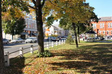
Downtown Lee, the western anchor of the Jacob's Ladder Scenic Byway, is a picturesque New England shopping district. It includes many historic structures and has been frequented by such notables as Edith Wharton and Norman Rockwell. Joe's Diner, on the north end of Main Street, was the setting for Rockwell's "The Runaway". Downtown Lee is a great place to begin or end your visit to Jacob's Ladder Scenic Byway. For more information contact the Lee Chamber of Commerce at 413-243-0852 or visit www.leechamber.org.
Click here for directions.
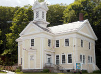
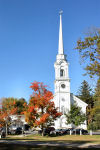 First Congregational Church in Lee.
This beautiful Italianate church, built in 1858, has the tallest wooden steeple in the country. The interior contains “trompe l’oeil” (fool the eye) stenciling, an excellent example of an almost-forgotten craft, and regarded as one of the finest examples of this work in the U.S. The choir loft and the 1927 organ are also noteworthy. Sunday worship is at 10:30 a.m., and community suppers are served Wednesdays at 5:30 p.m. For more information, call 413-243-1033 or visit www.ucc-lee.org.
Click here for directions.
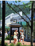 Prime Outlets at Lee.
Sixty-five manufacturer direct outlet stores, arranged in a New England village style setting, offer everyday savings of 25-65%. Located on the Jacob’s Ladder Scenic Byway (Route 20), just off of Exit 2 of the Mass Pike. For dining and overnight accommodations, visit historic downtown Lee, less than a mile away. For more information, call 1-877-GO-OUTLETS or visit www.primeoutlets.com.
Photo courtesy Prime Outlets.
Click here for directions.
October Mountain State Forest.The largest state forest in Massachusetts, October Mountain is terrific for hiking, XC skiing or other passive recreation. The Appalachian Trail passes through the State Forest, where it links with a number of other trails. See also "State Forests and Parks" and the Forest's website. For a trail map, click here.
Click here for directions.
 The Appalachian Trail.
The Appalachian Trail, America’s longest walking trail – 2,175 miles long, 90 miles of which pass through Massachusetts, intersects the Jacob’s Ladder Trail in Becket. The Appalachian Trail (AT) was established during the 1920s partly as a reaction to the burgeoning of auto-tourism. To the north of Jacob’s Ladder Trail, the AT passes through October Mountain State Forest, Massachusetts’ largest state forest. To the south, the AT travels past scenic Upper Goose Pond. See also "Appalachian Trail" or check these websites for more information:www.nps.gov/appa/ for the official site and www.fred.net/kathy/at.html for a private site
Photo by Steve Goodrich.
Click here for directions.
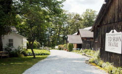 Jacob’s Pillow Dance Festival.
America’s premiere international dance festival is located on the site of Becket’s historic Carter Farm, which dates from 1790. The “Pillow” is an international venue for dance performance and education, founded in the early 1930s by modern dance pioneer Ted Shawn. Today this 163-acre facility, designated a National Historic Landmark, is open to the public from June through August. For information on current programs and events, call 413-243-0745 or visit www.jacobspillow.org.
Click here for directions.
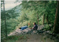
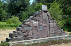 Jacob’s Ladder Trail Summit and Stone Cairn.
Jacob’s Ladder Trail ascends to its highest elevation of 1,775 feet at Morey Hill, in the town of Becket. The summit is marked by a stone cairn originally placed there for the gala inauguration of the highway in September 1910. The cairn and the former summit house are all that is left of what was a very popular destination in its heyday. Nearby were Jacob’s Well and Jacob’s Spring: as the cars of the early 20th century often become overheated climbing the hills of Jacob’s Ladder Trail, this was an important stop for water.
Click here for directions.
 Becket Arts Center of the Hilltowns.
The Becket Arts Center is housed in a fine example of an 1855 Greek Revival schoolhouse, located at the intersection of Route 8 and Brooker Hill Road in Becket Village (several miles north of the Jacob’s Ladder Trail). It houses two galleries presenting exhibits and workshops from June to Labor Day. For information, call 413-623-6635 or visit their website at www.becketartscenter.org.
Click here for directions.
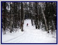 Canterbury Farms Cross-Country Skiing.
Canterbury Farms’ trail system was specifically designed for cross country skiing, and it has recently been adapted for ski skating as well. Twelve miles of trails are groomed and tracked daily. With a northern exposure, nestled high in the Berkshire Foothills, the facility gets the best snow in the area. Surrounding the Farm are 2,000 acres of state and private forestlands, allowing for wilderness skiing as well. The Farm’s staff is available to fit guests with the proper ski equipment or provide lessons if needed. The Berkshire Room of the farmhouse has a cozy fireplace and hot food and drinks. For ski rates, lessons, and packages call (413) 623-0100 or log onto www.canterbury-farms.com. For a trail map, click here
Photo courtesy Canterbury Farms.
Click here for directions.
First Congregational Church of BecketThis church pre-dates the American Revolution. The area known as the 'parade' in front of the church was used by Becket Minutemen for drills in 1775. The church boasts a bell cast by Paul Revere which is still in use today.
Click here for directions.
Pine Hill Cemetery.Established in 1834, this Victorian-era cemetery, located atop of Pine Hill in Chester, offers scenic views of the Westfield River Valley. Many of the headstones were cut from Chester granite and slate by local stone cutters. This cemetery is still used by Chester residents.
Click here for directions.
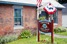
 Miniature Theatre of Chester.
Founded in 1990, this Theatre presents plays featuring renowned stage actors, from the first week of July through Columbus Day weekend. The Theatre uses the auditorium of the Chester Town Hall for its productions. For information, call 413-354-7771 or visit www.miniaturetheatre.org.
Click here for directions.
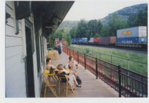 Chester Railroad Depot and Museum.
This museum, located in the restored depot at the end of Main Street, houses trains, railroad memorabilia, and artifacts from Chester’s railroading days. Built around 1841, it was operated for many years along the line from Springfield to Albany, New York. Exhibits include the Children’s Heritage Boxcar Museum, and the depot is surrounded by a variety of historic railroad cars, including a 1923 tank car, a 1919 wooden caboose, and a 1929 restored wooden boxcar. The museum is by appointment. For information, visit their website at www.chesterrailwaystation.net/.
Click here for directions.
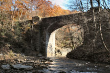 Keystone Arch Bridges and Trail.
The Keystone Arch Bridges, located in Chester, Becket and Middlefield, Massachusetts, the series was the first system of bridges of their kind built for railroad use in the United States. These 70-foot high stone bridges, built without mortar or steel reinforcements, were built between 1833 and 1841, extending the Western Railroad across the deep gorges of the Westfield River on its route to New York. Major George Washington Whistler, father of the artist James Whistler, and William Gibbs McNeill were the chief engineers responsible for designing the bridges. The five remaining Keystone Arch Bridges are in the Middlefield-Becket Stone Arch Railroad Bridge District on the National Register of Historic Places. The Keystone Arch Bridges Trail extends for 2.5 miles and provides the only public access to two of the bridges. The trail also provides beautiful views of the West Branch Gorge of the Westfield River, the first National Wild and Scenic River designated in Massachusetts. The hiking trail to the Arches originates off of Middlefield Road in Chester. A self-guided tour map is available at the Chester Railroad Museum. Visit the website at http://keystonearches.com/ or call 413-354-7752 to arrange a guided tour.
Click here for directions.
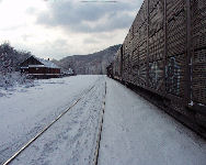 Boston and Albany Railroad.
In 1841 the opening of the Western Railroad forever changed the towns along Jacob’s Ladder Trail. The rail line, which is still in use today, later became the Boston and Albany Line. It was designed by George Washington Whistler and remains one of the steepest rail grades in the United States. Among the engineering feats accomplished by Whistler and Scottish mason Alexander Birney are the colossal keystone arch bridges in Chester and Middlefield. The only remaining Western Railroad depot, ca. 1840, is located in Chester Factory Village and serves as a railroad era museum.
Click here for directions.
 The Old Chester Jail.
This tiny 19th century jailhouse is used as an historical museum, including a display of an enormous carborundum grinding wheel, formerly manufactured by local factories. Open the first Wednesday of the month, 9-11 a.m. or by appointment. For information, visit their website at www.chestermass.com/Chester_Historical_Society/ call 413-354-7820.
Click here for directions.
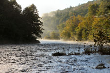 Westfield River.
The Westfield River, a nationally designated Wild and Scenic River, flows through much of the Jacob’s Ladder Trail region. With headwaters in the Berkshire Hills, the Westfield River traverses some of the wildest areas in Massachusetts, as well as cultivated landscapes of maple-shaded farms and historic villages. In the spring, the river attracts hundreds of paddlers from the eastern United States for the excellent whitewater canoeing and kayaking at the annual river races.
Click here for directions.
Chester Center on Skyline Trail.This intact 18th and 19th century village that includes an old burial ground is surrounded by blueberry fields, open pastures, and sheep and cattle farms. The crest of Skyline Trail offers splendid views across the valley formed by the Westfield River. In early spring, the Chester Hill Association holds the Maple Festival, during which farmers along Skyline Trail open their doors to the public, serving up pancake breakfasts, demonstrating the making of maple syrup products and offering horse-pulled hay rides.
Click here for directions.
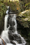 Chester-Blandford State Forest.
Created by the Civilian Conservation Corps during the Depression, this forest contains Sanderson Brook Falls and Goldmine Brook Falls, a semi-primitive campground and numerous hiking trails, including the Newman Marsh Trail which offers spectacular views of the Westfield River Valley. It also includes the Boulder Park Accessible Trail, described below. See also "State Forests and Parks", and you can visit the park's website. For a trail map of this state forest, including the Newman Marsh Trail and the Boulder Park Accessible Trail, click here
Click here for directions.
H. Newman Marsh Memorial Trail.Located in the Chester-Blandford State Forest, this marked trail of 1½ miles leads to Observation Hill, a 1,200-foot summit with spectacular views of the Berkshires and the Wild and Scenic Westfield River Valley. Access and parking are available on Sanderson Brook Road in Chester, across from the Bannish Lumber Company. See also "State Forests and Parks"
Click here for directions.
Boulder Park Accessible Trail.Boulder Park was constructed between 1934 and 1936 by the Civilian Conservation Corps (CCC) to offer swimming, picnicking, hiking and skiing. The park, part of the Chester-Blandford State Forest, is named for its high concentration of huge boulders, called “erratics,” dropped by glaciers 15-18,000 years ago. An accessible trail winds through the park, providing access to several sitting areas, views, a pavilion, and several interpretive signs describing the history and geology of the park. See also "State Forests and Parks"
Click here for directions.
Littleville Dam & Lake.The Littleville flood control dam and recreational facility was built in 1963 in response to the devastating 1955 Westfield River flood. The two-and-a-half mile long impoundment created by the dam is popular for fishing and canoeing.
Click here for directions.
Gardner State Park.Named for the former national president of the Grange Association, Charles M. Gardner, this park is popular for picnicking, and for swimming and fishing in the nationally designated Wild and Scenic Westfield River. See also "State Forests and Parks" and visit the park's website
Click here for directions.
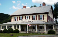 Huntington Country Store
A delight for visitors of all ages, this old-fashioned country store has gifts and goodies everywhere you look. Don't miss the ice cream bar! See the Huntington Country Store website for more information.
Click here for directions.
Knightville Dam & Wildlife Management Area.This flood control dam, built in 1941, has a 1,200 foot long earthen embankment which stores water during flood conditions in a six-mile long reservoir. The basin contains second growth forest that is habitat to native New England fish and wildlife. Among the many recreational opportunities are catch-and-release trout fishing and hiking trails. Located at the northern end of the basin is Chesterfield Gorge, a Trustees of Reservations property that is open to the public.
Click here for directions.
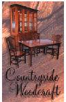 Countryside Woodcraft.
A showroom of crafted-on-site furniture in Shaker, Mission and Nantucket styles, this family owned and operated business has developed a reputation for craftsmanship and durability in the tradition of the Mennonite culture. See the Countryside Woodcraft website for more information.
Photo courtesy Countryside Woodcraft.
Click here for directions.
 Hill & Dale Rapids.
This is a popular viewing spot for the annual Westfield River Wildwater Race, the longest continuously held whitewater race in the country. During spring flood, when the river is at race level, this section of the Westfield River is a class 3 rapids. For more information, visit www.westfieldriverraces.com
Photo courtesy Inner Mountain Photography.
Click here for directions.
General Knox Marker.A 1927 marker memorializes General Knox’s crossing of the ridge of Glasgow Mountain during the Revolutionary War. Knox and his troops were marching with the cannons from Fort Ticonderoga, New York to Dorchester Heights in Boston. The arrival of the cannon forced the evacuation of the British. General Knox wrote in his diaries that this section of the trail was the most difficult portion of the entire trip.
Click here for directions.
Cobble Mountain Reservoir.The largest of three reservoirs built between 1910 and 1930 to provide water to the city of Springfield, Massachusetts. This inland lake was created by an earth-filled dam that was the world’s highest at the time of its construction. (Unfortunately, this site has been closed to the public since 2001)
Click here for directions.
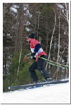 Blandford Ski Area.
This ski area has been owned and operated by the Springfield Ski Club since 1936 and is the oldest continuously operating club-owned ski area in North America. Located just ½ hour from Springfield, the ski area offers exciting downhill skiing, ski sales, and ski instruction. The Blandford Ski Area is located on 2nd Division Road in Blandford, just three miles off of the Jacob’s Ladder Scenic Byway. For ski conditions, call 413-568-4341, and for more information, visit www.skiblandford.org. Click here for a trail map.
Photo courtesy Pierre Catellier.
Click here for directions.
Tekoa Mountain Wildlife Management Area and Rattlesnake Sanctuary.This rugged, steep-sided mountain marks both the mouth of the Westfield River canyon and the eastern end of the Jacob's Ladder Trail. The canyon was formed by the erosion of the highlands by the river over the millenia following the last Ice Age. Purchased in 2000 by the Massachusetts Department of Environmental Management, Mt. Tekoa has been designated as a rattlesnake preserve.
Click here for directions.